Located deep in the rugged, wooded hills of southern Missouri, the area now included within the boundaries of Ripley County remained sparsely settled throughout the nineteenth century. Although officially organized in 1833, the county did not assume its present size until 1872.
When Congress created the Territory of Missouri in 1812, what eventually became Ripley County lay within New Madrid County. Three years later, Lawrence County was established, which include all of southern Missouri west of the St. Francis River as well as a portion of northern Arkansas. The seat of justice for Lawrence County was located at Davidsonville in present-day Arkansas. The administrative configuration of southern Missouri changed again in 1818 with the creation of Wayne County. This massive county included nearly one-fifth of the area lying within the Missouri Territory, Greenville became the county seat.
In 1833 the General Assembly established Ripley County from a portion of Wayne County. At its creation, the county included the area comprising present-day Ripley, Carter, Shannon, Oregon, and Howell Counties, with Van Buren as the county seat. The county was named for War of 1812, General E. W. Ripley. Over the next twenty-six years, Ripley's boundaries decreased as new counties were formed-Shannon (1841); Oregon, which include today's Oregon and Howell Counties (1845); and Carter (1859). The last boundary adjustment occurred in 1872.
Because most of the population was in the southern half of the county, voters decide to move the county seat to the newly platted Doniphan, nearer to the center of population and a wooden courthouse was built. This building served the county until Union troops burned it, and most of Doniphan, in 1864. Fortunately, William Russell, a county official, had earlier removed the county's record books from the courthouse and placed them in a cave south of town. They remained hidden until retrieved by the county clerk in 1867.
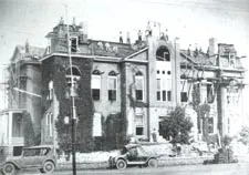
Because of the chaos and destruction brought about by the Civil War, Ripley Countians did not replace the courthouse until 1871. A two-story brick courthouse resulted from the $10,000 bond passed by the county's citizens and housed the administrative offices until destroyed by fire in January 1898.
Ripley County's current courthouse was designed by William F. Schrage of Kansas City and built in 1898 1899. A central tower, later destroyed during a 1929 tornado, dominated the two-story brick structure. Federal relief workers undertook some repairs and renovations of the courthouse during the 1930s. Not until an extensive remodeling project completed in the 1970's, however, was central heating incorporated into the building. The century-old courthouse is now listed on the National Register of Historic Places and celebrated its centennial during the 1999 Labor Day Homecoming Festivities.
Ripley County Government
Ripley County is a Third Class County administered by a three member County Commission. One Commissioner from each of two County Districts join a Presiding Commissioner elected at large for terms of four years. The County Commission allocates the County property taxes, road taxes and sales taxes which are levied for County purposes. It has general supervision of the County public roads and maintains the Courthouse and other County buildings. It oversees the budgets of a number of independently elected officers such as the County Clerk, Sheriff, Prosecuting Attorney, Coroner, Public Administrator, Assessor, Collector, Treasurer and Surveyor.
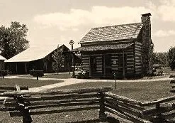
The area that became Doniphan was permanently settled as early as 1819 when Lemuel Kittrell homesteaded on a bluff above the east bank of Current River near the site of a French trader's cabin. Kittrell soon built a grist and wood carding mill near his home and attracted additional settlers to the region. By 1841, a sizeable village had grown near the Kittrell home. The village became a regular stop on the Butterfield Stage Line and was on the St. Louis to Little Rock Highway. In addition to the mill, the village boasted of an inn, store, distillery, produce warehouse, tannery, justice of the peace and notary office, blacksmith and gunsmith. A school was nearby.
On the hills above lovely Current River, Doniphan was founded and became the county seat of Ripley County in 1847. George Lee gave 50 acres for the town and named it for Mexican War Colonel Alexander W. Doniphan. Except for the mill, all of the businesses at Kittrell's Mill moved to the new town and were joined by several additional stores and businesses. Churches, too, were added. Doniphan became the regional center of commerce. By 1860 there were plans to extend the St .Louis, Iron Mountain and Southern Railroad from Pilot Knob to Doniphan. The Civil War changed those plans.
Most residents of Ripley County, as well as the surrounding counties, were Southern in belief. Several Confederate regiments were formed in the county and one, the 15th Missouri Cavalry Regiment, CSA, was based at Doniphan. Because three major north-south highways passed through Ripley County, fighting was practically constant during the war.
In the war, brutal guerilla bands overran the county and in September 1864, Doniphan was burned by Union troops as Confederate General Sterling Price's army was moving into Ripley County from Arkansas. Devastated by the war, Doniphan grew with the coming of a branch of the Missouri Pacific Railroad in 1883. The railroad provided a means to market the thousands upon thousands of acres of virgin timber surrounding Doniphan, native yellow pine logs, hauled to Current River and floated to Doniphan in enormous log drives. A log boom at Doniphan retrieved the logs, which were milled and finished, then shipped to market. Hardwood logs were normally hewed into crossties, then collected on the riverbank and moved to Doniphan by long tie rafts. During the early 1900's, Doniphan was the center of a leading railroad tie producing area in the U.S. At the peak, the Missouri Tie and Lumber Co. cut some 35,000,000 feet of logs a year in northwest Ripley County. After 1905, the denuded land was uncared for until made a part of the Clark National Forest in the 1930's when it was put under a program of reforestation.
As other land was cleared by loggers, farmers moved in. Many orchards were planted, some very large. Elberta peaches were the major fruit crop, but apples and pears were also important and tomatoes were grown commercially. Strawberries, too, were a major crop. Several produce warehouses and canning factories were located at Doniphan because of the railroad. Corn, wheat, and cotton were major crops. A roller mill at Doniphan manufactured the very fines grade of flour. In the 1920's and 1930's, the depression changed life in Doniphan, practically halting logging and production and stopping the exports of farm produce.
World War II brought about renewed vigor for Doniphan business and the establishment of new industries, particularly the Hunt Garment Factory and the Wright Leather Specialty plant. Today the industrial structure at Doniphan has greatly enlarged and is a substantial employer. Logging is still a major enterprise with many family owned mills in the area. Because of the crystal clear waters of the Current River, the scenic views in the Mark Twain National Forest and the favorable climate of the Ozarks, tourism is becoming big business at Doniphan.
City of Doniphan Government
Doniphan was established as a village April 26, 1847 and has served Ripley County as County Seat since that time. Doniphan became classified as a Fourth Class City May 1, 1891. The form of government is Mayor and Alderman. A Mayor is elected to preside over a four member Board of Aldermen, all of whom serve in staggered terms for two years. The Municipal Election is held in April of each year. Also elected is a City Collector. The Mayor is the Chief Executive Officer of the City who appoints, subject to Board Approval, all other non-elected officers of the City. The City Clerk, elected by the Board of Aldermen, is the Budget Officer of the City and handles most of the administrative affairs of City Government.

City of Naylor
The land that is today the town of Naylor, was earlier Barfield, being first settled by the Lewis K. and Sarah Barfield family a few years prior to 1859. The family had come to the area from Kentucky via Illinois. The Barfields were held in high esteem as evidenced later when there was great resistance to changing the name of the town.
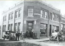
The Barfield community did not come into existence until the Iron Mountain branch of the Missouri Pacific railroad came through in 1882 and went on to Doniphan. That same year Jasper McKinney opened a sawmill and a stave mill. The next year Edward Punch opened a store, the town was laid out, a post office was established and Barfield had a population of 75 and was growing. By 1889 there were 200 residents and in 1893 the population was 500. That year the town put up a city hall and a jail and had a fairground and a racetrack.
The Horton Land and Lumber Company made its headquarters in Naylor in the late 1880s and built a large sawmill south of the railroad tracks that employed approximately 500 loggers, lumberjacks and sawmill hands. A tram railroad was built south into the forested area and logs were hauled to the mill. The Horton brothers were Poplar Bluff bankers and their company specialized in making Victorian home kits that were sold by mail order throughout the Midwest. A model home designed to show the types of lumber that were produced at the Horton mill was put up in 1892 and was company headquarters for a time. Today it is listed on the National Register of Historic Places.
When it became apparent that the freight was being misrouted because there was also a Barfield, Arkansas, mill officials recommended the town's name be changed to Naylor in honor of William A. Naylor, a former Union army captain from Indiana who was the county's land surveyor. Although the name of the city was not officially changed until 1910, the name Naylor was adopted for all practical purposes on Sept. 23, 1892 when the post office was renamed.
The Horton Company sold out to the Kelsy Lumber Co. which ran the mill until it burned in 1896. With big timber running out, Naylor began to decline, but the Frisco Railroad built a line from Cape Girardeau to Hoxie, AR in 1902. Things began to improve as Naylor was now on a railroad crossroad. On August 30, 1905 it became a fourth class city, a seal was adopted and voting precincts were set up.
Cotton was a good crop for the southeastern part of Ripley County and Naylor had two cotton gins at one time. The school would take a "cotton" vacation when the cotton was ready to be picked. People would gather and visit while the cotton was being ginned, bringing a bit of carnival atmosphere to a normally quiet town. In the 1920s and up until about 1960 cotton was king in southeastern Ripley County. Picking cotton during the depression paid about 50 cents per hundred pounds. Many men could pick 200 to 300 pounds a day. By 1960 the cost of fighting the boll weevil made milo, soybeans, wheat and rice more attractive crops and cotton crops dwindled.
Today, with a Mayor and a City Council, Naylor is the only other incorporated town in Ripley County. It has a modern school system, water system, fire department, bank, family clinic, restaurants, two grocery stores, several churches and all the other ingredients of a small town with a population of 642.
Naylor Government
The City of Naylor, Missouri is the only other incorporated Municipality in Ripley County, Missouri, with a population of 610 residents according to the 2000 Census. It is a Fourth Class City with a Mayor-Council form of government. A Mayor is elected to preside over a four member Board of Aldermen, all of whom serve in staggered terms for two years. The Municipal Election is held in April of each year. Also elected is a City Collector. The Mayor is the Chief Executive Officer of the City who appoints, subject to Board Approval, all other non-elected officers of the City. The City Clerk, elected by the Board of Aldermen, is the Budget Officer of the City and handles most of the administrative affairs of City Government.